Over the past few weeks we’ve covered what an EM Survey is,
and the different benefits of completing one on your farm. But what I’d like to
do today, is give you a bit of an insight into how we at Agri Optics do an EM Survey,
ensuring that you receive top notch quality data to help with your ‘precision
decisions’. So here we go…
Our surveyor arrives at the farm nice and early. When we get
there the gear needs to be all unpacked out of the trailer and set up for the
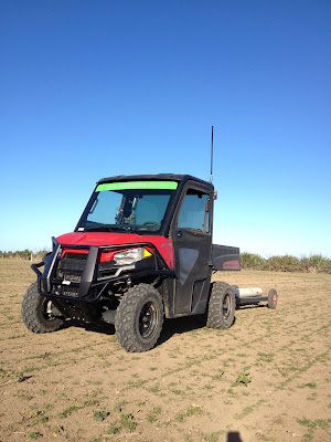
day ahead. Our Polaris needs to warm up and while this is happening the Trimble RTK GPS base
station is set up ready for logging the
DualEM data. This base station is highly accurate and gives us horizontal
accuracy of +/- 2cm.
Next, we need to plan the survey in conjunction with the
farm manager (this often happens before we come on site to do the survey),
starting with areas that need to be done first for management reasons, such as
working around cows in paddocks etc. Additionally we need to know of any
hazards and other features that might influence the survey, such as buried wire
guidance, pipes, etc. Once we know all these factors we get on with the job.
To complete the survey we drive the Polaris towing the DualEM
around the outside edge of the paddock, once near the fenceline and the second
time a few metres in from this. Then we drive up and down at 12 metre intervals
along the length of the paddock at approximately 15km per hour. The spacing and
consistent speed is important in collecting and processing quality data across
the entire survey. We use AB guidance lines on our Trimble FmX to ensure that we drive as
straight as possible and reduce overlap which would cost us time and you money.
We then complete the survey of the rest of the paddocks in the same way –
around the outside and then up and down along the paddock.
(excuse the video, it's a bit shaky sorry!)
As we all know, electronic equipment can be slightly
temperamental sometimes and we need to put a few checks in throughout the day to
make sure that the DualEM sensor is running as it should. To do this we
re-survey transects across previously surveyed areas a few times during the day,
making sure that the readings don’t change and ensuring the DualEM is working
to its maximum potential.
So, now we’ve completed surveying on all paddocks for the
day and have ensured that the data is high quality data by performing these transects
and doing a few checks. We then look at the raw (unprocessed) DualEM data out
in the field and pick out a few areas that show different EM readings. We go to
these points and take soil cores using a corer that is 2.5cm in diameter and
30cm long. We complete a visual observation of the soil, relating these to the
EM map. The cores are taken as deep as we can possibly go and then placed carefully
on a tube with depth markings on it. With the cores carefully lined up on this
marker, we then take notes on parameters such as the depth of topsoil, amount
& size of stones, textural properties at different depths and so on. All of
these properties help add to the understanding of the final EM map.
After this the day is almost done. Clean the gear and pack
it away safely for next time before the surveyor goes home for the night to
look at the EM data collected during that day on their laptop and get a good
nights rest ready to do it all again tomorrow.
Blog post written by Jemma Mulvihill from Agri Optics NZ
Ltd. To find out more about EM Surveying or any of the topics discussed in this
blog call Jemma directly on 021796124 or visit the Agri Optics website.


